guangming office: historic questions of translation

Speakers of North American English such as myself often fall into linguistic rabbit holes when reading official Chinese documents. My confusion arises from what both Western Marxists and Chinese Party members might call “historic questions/ problems of translation (翻译的历史问题)”. Thus, although their are semantic overlaps, a city is not a 城市, an office is not a 办公室, a community is not a 社区, and a collective is not a 集体 because the respective geographies of the USA and PRC have been formed through vastly different cultural ecologies and property regimes. Continue reading

shekou relaunch

So the Biennale has been extended two weeks. Good news and great press for the curators, the SZ Center for Design, and China Merchants. And that–generating a Shekou Buzz–has been the point of all this productivity, or as the current campaign is called “Shekou Relaunch”.

This afternoon, I attended one of the final scheduled events, a forum on how to renovate the Dacheng Flour Mill, which has been designated the site of the future Shekou a Industrial Culture Center. The program included repurposing the buildings and designing more public space, a visual culture center, a theater, and an office building. The responses hinged on determining the purpose of the renovated buildings; just what does China Merchants hope to accomplish through these renovations? Just what is being launched again? And why?

Indeed, there is both something primal about the campaign; we are setting off, again (再出发), and yet something equally unsettling; again? How many times do we need to remake society? Or is it just the persistent dissatisfaction of capitalism and vague anxiety that we may never get it right?

I actually believe that creative activity makes people happy, but not redundant assembly line production. I have experienced happiness in creative activity that nourishes my connections with others. I am particularly enjoying 302 because it brings together research interests, social commitments and friendships. I also really, really like working with my hands. This seems to me the goal of social transformation; improving the quality of life of family, friends and neighbors, and not just achieving higher economic indicators.

Today, I’m thinking that to the extent that traditional socialist industrial culture aimed to improve the lives of worker, it offers inspiration for possible renovations and building. However, without a discussion about what’s being relaunched and why, another round of pretty and smart and interesting construction seems to me to be beside the point.

laying siege to the villages: the nantou peninsula

A five-part essay, “Laying Siege to the Villages” has been published online at Open Democracy. Here’s part two on the Nantou Peninsula.

2. Concentric Occupations: Nantou Peninsula

The built environment of Shenzhen urban villages references three historic moments – late Qing and Nationalist-era rural society, Maoist collectivization, and post Mao reforms. Spatially, this history has been expressed as concentric occupations, with the oldest sections being first appropriated and then surrounded by newer developments. In turn, older settlements have been downgraded and converted into low-income neighborhoods. Locally, this process has been called, “cities surround the countryside”, which not only resonates ironically in post Mao China, but also identifies poverty with rural status. Maoist theory and practice had identified cities with all that was foreign and reactionary, and villages with all that was truly national and revolutionary. In contrast, the elevation of Bao’an County to Shenzhen Municipality began the administrative transvaluation of the rural-urban relations, which was formalized in 1982 Chinese Constitution.

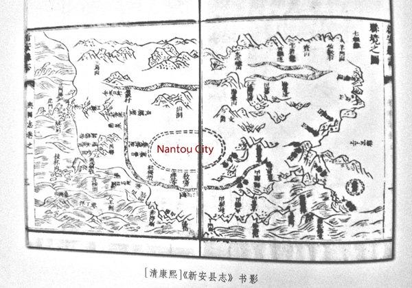
Over 1,000 years ago, salt fields were developed in the Shenzhen-Hong Kong area, and the yamen for the local salt intendant was located on the Nantou Peninsula. The area was also famous for its oyster and pearl production. The peninsula provided protected harbors and access to Guangzhou via the Pearl River. During the Ming dynasty, the Shenzhen-Hong Kong area was called Xin’an County and Nantou City was designated its County Seat. Located on the southeastern banks of the Pearl River, Xin’an was historically poorer than the counties on the eastern banks. Nevertheless, the harbors of the Pearl River’s eastern coastline were significantly deeper than those on the western coastline. Consequently, Chinese maritime access to the South China Sea traditionally went through Humen (in neighboring Dongguan) and Nantou. Indeed, Zheng He’s fleet stopped at the Tianhou Temple in Chiwan Harbor on their voyages of exploration (1405-1433), which took the Ming explorer as far as Africa. After the Ming ban on ocean travel made it possible for pirates to control the South China Sea, Guangzhou remained the southern gate to China and the ports on the eastern coast of the Pearl River became even more coveted by international traders (map 2).

nantou old city

Map 2: Xin’an County Seat in the Reign of the Kangxi Emperor (1661-1722)

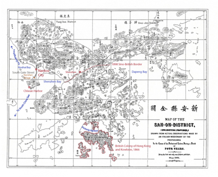
By the late 18th Century, Guangzhou had not only become and important financial center, but also the center of opium trade. The first Opium War ignited when Lin Zexu dumped the opium stocks of British traders in the Pearl River. In turn, the traders successfully pressured the British government to use military means to secure compensation for their losses. China’s defeat in the Opium Wars resulted in British colonialization of southern Xin’an, including Hong Kong Island, the Kowloon Peninsula and the New Territories. The Sino-British border was drawn along the Shenzhen River and passed just south of Shenzhen Market (map 3). The laying of the Kowloon-Canton Railway in 1913 further shifted the flow of goods and people toward Hong Kong and away from Nantou. Small-scale trade between settlements on the Pearl River continued, although Nantou no longer played a dominant role in the regional political-economy. Instead, Shenzhen Market, the first station on the Chinese side of the KCR became the political and economic center of Xin’an County, which was renamed Bao’an at the start of the Nationalist era.

incursions

Map 3: Riparian Trade Routes, Nantou City, and British Incursions

In fact, the establishment of Shenzhen explicitly invoked colonial history, making the return of Hong Kong to Chinese sovereignty one of the key political impulses behind economic liberalization. Maoist modernization of Nantou, for example, included a two-lane road (today known as New South Road), which was laid parallel to the ancient South Gate Road and connected the peninsula villages to the national railroad and highway system. In the post Mao-era, however, state investment has aimed to urbanize the area, rather than to integrate rural settlements into the state apparatus. Land reclamation of Pearl River coastline gives the clearest indication of the scale and ambition of these plans – replacing Hong Kong and possibly even Guangzhou in the global organization of South China trade.

The reform-era transformation of the Nantou Peninsula illustrates the broad contours and social contradictions that have characterized “cities surround the countryside”. During the Ming Dynasty, a pounded earth wall enclosed Nantou, but by the time of the first Opium War, the wall had crumbled into disuse and only the southern and eastern gates still stood. A road stretched from the decrepit Southern Gate and along the coast of the Pearl River to Nanshan Village, which was located at the foot of Nanshan Mountain. Between Nantou Old City and Nanshan Village six villages – Guankou, Yongxia, Tianxia, Xiangnan, Beitou, and Nanyuan – claimed land that included access to the Pearl River, a portion of South Gate Road that they identified as Village Main Street, and farmlands that extended inland. However, through land reclamation and the emplacement of a grid of four- and six-lane roads, such as Qianhai Thoroughfare, Shenzhen’s rural origins have been surrounded and isolated South Gate Street neighborhoods from the larger city (map 4).

 surrounding the countryside

Map 4: Cities Surround the Countryside: The Nantou Peninsula

…a village by any other name…

Huaxin Village is not a village. Located at the intersection of Huaqiang and Hongli Roads, Huaxin was one of the earliest residential areas built in Shenzhen. It boasted 30 lowrise apartment buildings, a business office, and an office for neighborhood offices. In total, the neighborhood had 1007 homes. Walking west, the neigborhood abutted Fuhua Village and then opened into the northern section of Shenzhen’s Central Park.

To walk this area is to get a sense of the excitement and utopian discourse that permeated early Shenzhen. Huaxin literally means “China New (华新)”, Fuhua means “Prosperous China (福华)”, and Huaqiang means “China Strong (华强)”. Moreover, in the 1980s, the area north of Hongli Road was considered suburban with respect to the Dongmen and Luohu areas near the train station. Consequently, planning in this area primarily included factories and residential neighborhoods, such as Huaxin.

The layout of Huaxin  illustrates early understandings of public space and semi-public spaces. In addition to a public garden, the residential area also had a soccer field and areas for sitting and chatting. Moreover, along walkways, designers had included planters. When Huaxin housed the young SEZ’s managerial class, the ornamentals filled the planters. Over the past decade, the value of the housing stock has declined, even as property values have increased dramatically leading to a typical “urban village” phenomena: the owners have moved out and rented their homes to working families. In turn, these farmer-migrants have converted the planters to urban vegetable gardens, while first floor homes have been repurposed as shops.

Despite the value of the land, it’s not easy to raze rennovate these old, centrally located neighborhoods because the housing belongs to old Shenzheners, who — again like local villagers — are in negotiation with developers and the city to transfer the property rights. Again, compensation buy-outs are figured by square meter of housing. As early as April 15, 2009 — almost four years ago — there was news that Huaxin would be razed and the area upgraded. By 2011, DZT had published a feasibility study of how to upgrade the area inline with its position next to Shenzhen’s large electronics market, Huaqiangbei.

Of note du jour, in order to make these plans profitable, the new plans cannot include the same amount of space for urban gardening and semi-public gathering. Impressions of yesterdays walk from China Strong through China New past Prosperous China and into the northern section of Central Park, from where skyline views suggest the contours of thirty years of architectural and urban planning.

This slideshow requires JavaScript.

the shape of space: buji village #1

In the urban villages around the Old Buji Market (布吉墟), alleys and narrow roads wind upward, accomodating dense settlement and inadvertant public spaces. The most notable feature of the space is the proliferation of walls and determined privatization of small plots, or homesteads (宅基地). The isolating spatial organization of Buji reflects what urban planners disparagingly call “small farmer mentality (小农民意识)”. In practice, this means only investing in one’s own home, and minimal investment in public spaces and programs. Obviously, not only farmers have this mentality.  The Shenzhen Dream entails homeownership, while Tea Party populism represents one version of the US American  urge to privatize land and resources. However, the term “small farmer mentality” is usually a pretext for urban renewal programs that involve razing neighborhoods where the working poor live and replacing them with mall-burban settlements, where only the upper middle class can buy into the dream. Spaces like a Buji urban village  illustrate one of the key conundrums facing not only Shenzhen, but cities everywhere — creating livable neighborhoods for the working poor, rather than leaving urbanization in the hands of privatizing opportunists, whether they be individual farmers or employees of an urban planning board.

This slideshow requires JavaScript.

luohu culture park: the antidote to mall-burbia

DSCI0079 I prefer early Shenzhen urban planning to the rush to mall-burbia that is the current trend. Early planning assumed small scale, low cost urban living that promoted street life. In contrast, mall-burban developments raze central areas of the city to build large scale, high cost gated communities and attached mall, where security guards keep out the riff raff, effectively suburbanizing densely populated urban areas.

Luohu Culture Park (罗湖文化公园) exemplifies the latent urbanity of early Shenzhen planning. The 2,000 sq meter park includes underutilized cultural infrastructure, a lake, and my favorite kind of public art — a sculpture that children can easily appropriate. Continue reading

suzhou garden, huanggang, shenzhen

Visited the Suzhou style garden in Huanggang Village today. The Village axis runs from the arch on Fumin Road via a main street and the central plaza to the ancestral hall and temple. The garden is located behind the ancestral hall.

Also of note: in the main plaza, the village has crafted a self representation that mimics Shenzhen billboards, in which key buildings symbolize the strength and unity of the group. Nevertheless, unlike the municipal central axis, the village central axis runs east – west. Indeed, that’s the rub. If the central axis were opened up through the convention center, it would split Huanggang and plow through the garden.

Impressions, below.

This slideshow requires JavaScript.

as shenzhen razes: the baishizhou urban renewal plan online

Shenzhen developer, Lvgem Group (绿景集团) has uploaded a video of the Urban Renewal Plan for the Five Shahe Villages in Baishizhou (白石洲沙河五村旧改专项规划).

Wow. Just wow. And not in the good way.

The current built environment of roughly 580,000 square meters will increase 10-fold, to 5.5 million square meters.

The argument for razing the current settlement and replacing it with high, high rises and skyscrapers is that Baishizhou villagers live in grungy unpleasant conditions that need to be upgraded. The proposed solution is for the developers will work with villagers in order to bring them into the urbanization process.

In a nutshell,  the problem is that the video conflates the idea of “villagers” with the ruralized current residents of Baishizhou. There will be a resettlement area for “villagers”, but who counts as a villager? The actual population of Baishizhou is over 140,000, of which 120,000 do not have Shenzhen hukou. So, inquiring minds want to know: is the plan calling for ten times the space to house the 20,000 residents who do have hukou? Or does “villager” only refer to the actual members of the five villages, which means we’re talking about less than 2,000 people with resettlement rights. And if that’s the case, who will live in all this new, upgraded, hyper-modern space after the current residents have been forced to leave?

A quick visit to 58 net reveals how cheap housing in Baishizhou is relative to the surrounding area. In fact, many young office workers and professionals from neighboring Science and Technology Park (科技园) also live in Baishizhou as to designers and creative talents who work in the OCT Loft. Providing this class with livable (宜居) housing is an ongoing Shenzhen concern. Indeed, there is now an official plaque for hanging on a rental building which confirms a building’s livability.

It is estimated that over half Shenzhen’s population live in the villages, which account for roughly 10% of the area’s land. Arguably, the villages are the city, while high end housing estates and neighborhoods might be thought as wealthy suburbs, with lovely gardens and huge tracks of private spaces. Consequently, the question of who actually belongs to an “urban village” is the social, political, economic question because as Jonathan Bach has argued, the villages have been the incubators where (some of) Shenzhen’s migrant workers transform themselves into urbanites and potentially citizens.

As Shenzhen razes. Stay tuned.

…and the juggernaut rolls on

By the year 2017, Shenzhen plans to have built 95 shopping malls, totaling 17.8 million square meters. Moreover, the raze and raise juggernaut seems unstoppable, even in the face of growing support for historic preservation and public recognition of the social, cultural, and historic value of village settlements.

In October this year, the Municipality announced that  China Resources (华润) will raze Hubei Village and raise another high-end mall despite the fact that Hubei was built during the Ming Dynasty between 1465 – 1487, boasting a settlement history of almost 550 years.

The “three horizontal and eight vertical roads (三纵八横)” layout of Hubei exemplifies Guangfu (广府) or Cantonese style. The village also includes an ancestral hall that was rebuilt in 1804, a village gate, well, and over 200 houses. In addition, the ancestral hall used granite, a building material rarely seen in the area.

Hubei Village was part of the original Shenzhen Market (深圳墟), which has already been extensively razed. Indeed, Hubei Village is the largest and most concentrated of historical architecture in the area. Moreover, the village also serves as cheap housing for those who work in the surrounding hotels, spas, restaurants, and malls.

The recent and loudly protested decision to raze Caiwuwei and build the KK 100 is the immediate context for ongoing calls for some kind of preservation effort.

Impressions from a recent walk in Hubei, below:

This slideshow requires JavaScript.

shenzhen government online

Many readers come to this site looking for resources to learn about Shenzhen. In fact, as part of its efforts to make government more transparent, the Municipality has uploaded many of the key documents, which can be downloaded. The government’s main site is 深圳政府在线. Two of the sites that I find useful are:

深圳市规划和国土资源委员会 (for urban plans, including city and district level)

深圳统计局 (for statistics)

Also, to get a sense of what’s happening closer to ground level, the District governments all have virtual portals, which are differently helpful.

The six districts are: 盐田罗湖福田南山龙岗、and 宝安. The new districts (defined) are 大鹏坪山龙华、and 光明.

And a map of the territory: