Short update on all the tech stuff I’ve encountered today. I had breakfast with friends who said that they were using AI to read and summarize books for them and that while an expert might do better, DeepSeek was faster and more accurate than a young, just hired employee. I then when to Handshake for an event. Outside Nantou Ancient City, there was a robot sweeping the path to the south gate and a police robot that could take reports and photos. My day concluded with to a virtual exhibit on Pompei. Digital impressions of recent archaeology which allowed for the discoveries to be shown to scale, without giving a sense of the texture of anything. In fact, only the souvenirs were material. So we went through a virtual exhibition and could leave with high quality tchotchkes.
Tag Archives: nantou


ciao! nantou city
What does the invention of Belt & Road culture look like on the ground? Approximation du jour: it looks like a mash-up of classical European music, traditional Chinese martial arts, and a yearning to explore and trade and understand.
Continue readingpeeping
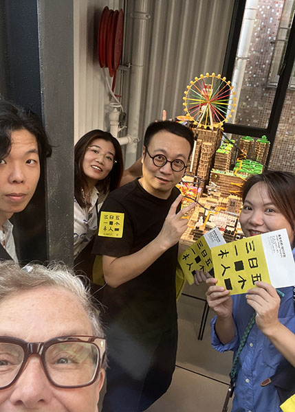
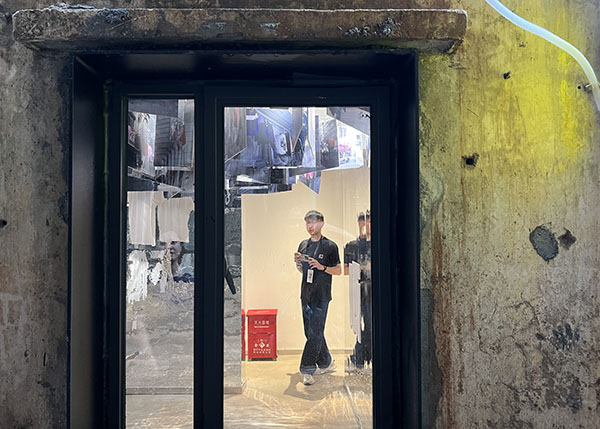
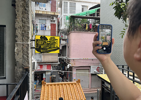
So the Nantou venue of the 2023 UABB finally opened on August 16. Rumor has it that the reconstruction of several handshakes was delayed. And delayed. And delayed. But. The results hover at the edge of critique, where showing is itself already taking a position, especially as what we can show and how it can be shown have been increasingly restricted. What I came away with was a sense of how windows function in tight, crowded spaces. We catch glimpses of our neighbors and strangers on their way, peeping across (necessary?) divides. Impressions of a walk through official biennale and adjacent spaces, below:


where have all the young folks gone…
no time passing… The melody is Pete Seeger’s, but the context is Shenzhen. Last night I was talking with friends, older friends of many years who have lived in Shenzhen since the early 1990s. We ended up talking about China’s population crisis and how it has been manifest in Shenzhen as the aging of menial laborers, the ongoing removal of affordable housing stock as urban villages are razed, and the flight of young families to cities like Changsha, which are actively trying to attract young people using methods that range from housing policy to social media campaigns to create a hip and friendly city image.
The current situation in Nantou illustrates how these issues come together on the ground. The sanitation crews for the area comprise older people, many who had joined their children in Shenzhen to take care of grandchildren, but once the grandchildren started attending school full-time found themselves both with time on their hands and in need of supplemental income. Many of these crew members are past the age of retirement and ineligible for retirement benefits in the city, making them a vulnerable workforce. In terms of affordable housing, Vanke has upgraded many of the handshake buildings on the two main streets in Nantou, replacing family housing with transitional rentals for singletons. Indeed, last time I went to Nantou, the rates for upgraded housing stock was 5,500 yuan a month, while older housing was still priced between 2,000 to 3,000 yuan, depending on location and size. Moreover, over two years of zero-Covid enforcement means that many mom and pop shops have closed up with generational implications. On the one hand, older entrepreneurs have lost accumulated capital and income. On the other hand, that wealth can no longer be passed on to children who may have been raised in Shenzhen, but do not have city hukou.
So yes, restructuring with a vengeance.
Continue reading
xixiang / bao’an / qianhai
I was playing with the 1866 map of Xin’an County (above) and ended up labeling three important sites on the map–Chiwan, Nantou, and Xixiang. These are the important sites on what used to be called Dachan Bay, and is now known as Qianhai. The reference to all these place names is “Nantou,” which is the colloquially name for the Xin’an County Seat. “Xixiang” means “Western xiang” because it was west of Xin’an. Qianhai means “Front Sea” and Houhai means “Back Sea,” and both are named with respect to Xin’an. Chiwan, of course, was the site of departure for the Western Seas in the Ming and then the South China Sea in the Qing.
The historical relationship between these three places has been gradually restructured since the establishment of the PRC in 1949. First, the County Seat was moved from Nantou to Shenzhen. In practical terms, this meant moving from the PRD to the Kowloon-Canton Railroad. It also meant that Xixiang became the most important town on Qianhai. Second, in 1979, the development of the Shekou Industrial Zone incorporated Chiwan into the new port area. Third, when the Second Line was fixed in 1982, it was drawn just north of Nantou. The new county seat was built up between Nantou and Xixiang. This new county seat was called Bao’an, after the rehabilitated name of the county.
Most recently, this area has been restructured as Qianhai, within the context of the Greater Bay Area. The borders of the Qianhai area run parallel to the coastline (new, reclaimed, but another story), but do not include Xixiang. In other words, what is being restructured as the city’s future are Shekou and Bao’an, while Nantou has been repositioned as a tourist site and Xixiang is on the rise as a residential area.
Below are some impressions of Xixiang, its history, and residential diversity.


nantou ancient city. again.
Sometimes, I walk through older sections of the city, and I try to remember what it felt like the first time I walked there. Or, if I can’t track my emotional memories, I try to remember what this place used to look like. Who was here? What were they doing? Did I take pictures or take notes and if not, where has it all gone?
Continue reading
SZ8X80108//The_Myriad_Transformations//Cut and Pastiche: Another City
“Cut and Pastiche” has played with the logic of montage in order to tease out the experiences and logics that comprised the Special Zone. Montage helps us understand the process because “Shenzhen” comprises diverse elements–factories and work units, migrants and locals, tradition and IT, brackish water and containers–which were already in the world, but needed to be reorganized in order for China to achieve its goal to modernize. Quickly.

SZ8X8//The_Myriad_Transformations
The Myriad Transformations comprises sixty-four images that I created using photographs taken between 2002 and 2010. These dates are arbitrary but not random, marking the purchase of my first digital camera (August 2002) and the decision to my rudimentary photoshop skills to create a project to commemorate the thirtieth anniversary of the establishment of the Shenzhen Special Economic Zone (during an artist residency at the Sitka Center for Art and Ecology, December 2008-January 2009). I finished the images in 2010. In the process of saving and transferring these files to smaller drives with larger storage capacity, many of the original photoshop files were lost. What remains as a complete set are the files I created to print photographs of the images in 2011 or 2012. I reopened one of these files in January 2019 and realized they were more interesting in retrospect than they had been when I made them precisely because over the past decade (2010-2020), Shenzhen has re-invented itself yet again, and suddenly, abruptly, we see the latent structure of today in images that once upon a time seemed definitive, eternal even. Continue reading

the left behind
Here’s the thing about the retreat of manufacturing from the townships and villages of the Pearl River Delta; these areas have urbanized, migrants have settled in and are raising families, but as the low-end jobs and shops that once sustained local and migrant communities follow the factories elsewhere, these neighborhoods are withering. Consider, for example, the older section of Dongguan–莞城, which only twenty years ago was a vibrant community and today is an abandoned reminder of the area’s complicated history with Ming pirates and British opium, its deep relationships with the late Qing Chinese diaspora, and the Pearl River Delta’s urban village origins. Old Dongguan has become a focus of concern for urban planners and concerned citizens: how to revitalize an “old street” that is no longer viable, but sits on prime real estate, or more precisely, inquiring minds want to know: to raze or not to raze historic areas and landmark buildings? Continue reading

first look at the belt and road
Its difficult when looking at a map of the proposed Belt and Road and not associate the maritime road with British colonialism, albeit in reverse and more than a century after the fact. But that’s what’s so distressing. When the British parliament dissolved the East India Company (EIC), it did not dismantle the systems of unjust and unjustifiable extraction that EIC had put in place over roughly four centuries of occupation, exploitation, and forced participation in the system. Instead, independence movements saw the rise of local elites who were determined to benefit from the system, justifying their profits with respect to local values and structures of oppression. In other words, it was never just the Brits, but also the Brits and their local running dogs (to use Mao Zedong’s felicitous phrase) and even after Independence, the dogs kept yapping, securing military support from the US and elsewhere (for the distressing tale of the fate of the Third World as a revolutionary ideal, check out The Darker Nations by Vijay Prashad).
The problem, of course, was that the profitability of the British system depended on opium; where would surplus profits (to fund industrialization, for example) come from without monopoly, forced labor, and addiction? Certainly, once India regained control of the Bihar plantations and China retook its ports, both countries were faced with the problem of “surpassing England and catching up with the United States” in the absence of captive markets and a drug monopoly to finance their industrial revolutions. And this may be why Europeans and US Americans fear the Belt and Road: if you’re not a running dog with Chinese characteristics, just what are your options in the new world dis/order (and yes, I’m looking at you, midwestern farmer)?
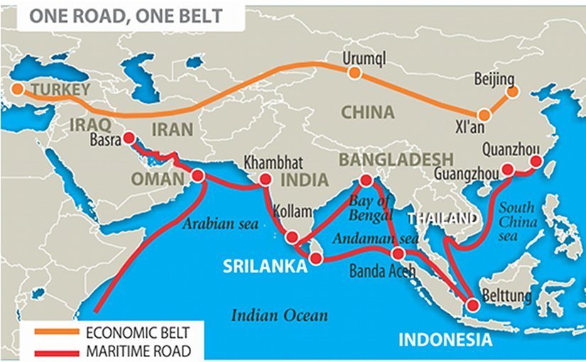
Map from an early analysis of Belt and Road, eurasia review.

Map of EIC trade routes from Nick Robins (2006) The Corporation that Changed the World: How the East India Company Shaped the Modern Multinational.
