utopian architecture

Utopian architecture in industrial Bao’an? Actually, yes. Developed over the past five years, the Wutong Island (梧桐岛–sometimes translated as Phoenix Tree Island) project combines Chinese ideas about nature, modernist architecture, and an evolving social vision for Shenzhen. Continue reading

shenzhen

So if you only have a couple hours to understand the city, you could do worse than visit the the Civic Center, its museums, the library and symphony hall, where Shenzhen asserts its global ambitions. The Museum of Modern Art is under construction, as is an urban planning exhibition hall. Impressions, below.

This slideshow requires JavaScript.

tantou: these are not mcmansions

This past week, I joined members of ATU on a research trip to Kaihua County, Zhejiang. ATU is a Shenzhen-based NGO, and their mission is to bring critical attention to architecture and urban planning practices. Most recently, they have decided to intervene in rural development in order to ameliorate the problems of bringing urban planning and its ideologies into rural areas. Continue reading

guanzhong folk art museum: dynastic architecturelandia

Located at the foot of Wutai Mountain in Xi’an, the Guanzhong Folk Art Museum (关中民俗艺术博物馆) is one of China’s more famous cultural tourism enterprises. In fact, the project launched billionaire peasant Wang Yongzhao (王永赵) into the National People’s Congress, where he has been recognized as a distinguished scholar. Continue reading

ten years ago…

I have been reviewing my photo archives and came across pictures of new village gates that I took roughly ten years ago. The pictures show village gates old and new and point to the persistence of community identity precisely because it is malleable to the needs of the present.

This slideshow requires JavaScript.

science fictionalized imaginations

The Shenzhen University School of Architecture is celebrating its 30th anniversary. The School of Architecture has a particular place in the university’s history because (1) the first president, Luo Zhengqi was an architect and (2) the first class of students, along with their teachers, actually designed the campus and its earliest buildings.

To commemorate its history, the school has organized a travelling exhibit of notable designs by 26 graduates. All of the designs had won important competitions and/or were being built; in this very practical sense, the work of SZU architecture students is shaping how contemporary Chinese architects are imagining, designing and building space.

Zhong Qiao’s (钟乔) designs for the Hu Yaobang Memorial, for example, inserts shiny white lines into the rolling hills of terraced rice paddies.Similarly, Zhu Xiongyi and Wang Zhaoming alos located their design for the Chinese National Gene Bank (Shenzhen) among terraced rice paddies. Even more explicitly futuristic, Zeng Guansheng’s design, Hong Kong Alternative Car Park Tower literally sends us flying.

On paper, these designs are delicately beautiful, and yet a sence of futurism and unlimited potential unites the designs. They are ambitious illustrations of contemporary China’s urban imaginary. Some designs examples from the SZU School of Architecture retrospective:

This slideshow requires JavaScript.

The show opened last Saturday on the first floor of the School of Architecture building. It will travel to at least 10 other schools throughout China, returning to Shenzhen for a conference organized by the Shenzhen Center for Design on October 19.

laying siege to the villages: xixiang and fuyong

A five-part essay, “Laying Siege to the Villages” has been published online at Open Democracy. Here’s part four, which discusses informal urbanization beyond the Second Line (erxian).

4. Informal Urbanization in the Outer Districts: National Highway 107

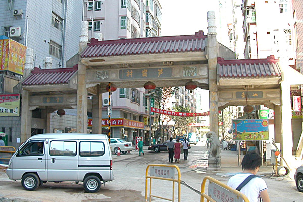
Shenzhen township and village enterprises (TVEs) in the outer districts (formerly New Bao’an County) were quick to take advantage of reform policies. By 1985, village-teams, township brigades, and the recently re-established Bao’an County government had already registered over 50 industrial parks (Map 6).

national highway 107

Map 6: Industrial Urbanization in New Bao’an County, 1985

Nevertheless, this massive social restructuring occurred outside and despite municipal urban planning (Map 7). A comparison of these two maps reveals three important features of informal urbanization in Shenzhen. First, the total area of Shenzhen’s informal industrial urbanization was over four times greater than planned urbanization in inner districts (original SEZ). Second, urbanization in the outer districts occurred outside official urban planning. Moreover, the density of industrialization along National Highway 107 becomes on the 1986 Plan an incomplete red thread. Indeed, as targets of urban planning, the outer districts did not appear in official maps until the release of the 1996 Shenzhen Comprehensive Plan. Third, the scale of development in the outer districts indicates the high level of informal organization in the villages. Informal urbanization did not arise sui generis, but through the redeployment of TVEs, which did not only represent the economic interests of the collective but also traditional identities and social constituencies.

guannei-wai

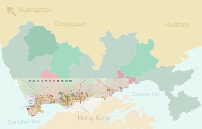
Map 7: 1986 Master Plan for the Shenzhen Special Economic Zone Transposed onto the 2013 Shenzhen Municipal Map

In addition to the New Bao’an County TVEs, the outer districts also saw the development of private stock companies formed by alliances between individual villagers and investors, often from Hong Kong or an Overseas Chinese community. The diversity of ownership, notwithstanding, all of these enterprises engaged in low-tech labor-intensive assembly manufacturing. The factories themselves were long, concrete buildings, usually 4-6 stories in height. These buildings usually had electricity and water hook-ups, and depending on the complexity of assembly, individual tables for detail work. Outside firms contracted a TVE to assemble a product according to spec. Earliest manufactured goods included textiles, toys, and cheap electronics. These early industrial parks also included 4-6 story dormitories for migrant workers. Dorm rooms were narrow, and fitted with four bunk beds. Opposite the door was a small window, while along the remaining walls two bunk beds were placed back-to-back. There was enough space between the bunk beds for residents to walk to their bed. Consequently, most conversations occurred sitting on a bed or outside on the lawn. Importantly, these factory complexes were built either along National Road 107 or the railway, along which goods were transported to the port of Hong Kong, where in turn the goods were shipped overseas.

In the early 1980s, when the Shenzhen TVEs opened, there were no other manufacturing jobs available to rural workers, who were still tied to collectives and mandatory agricultural production quotas through hukou status. This meant that the Shenzhen TVEs had labor reserves throughout Guangdong and neighboring provinces, where rural workers who were effectively excluded from wage labor. The number of migrants who took advantage of these opportunities constituted the Shenzhen population boom, transforming the landscape in three important ways. First, more people came than there were jobs and by extension, dormitory space. This created an immediate need for rental properties. Second, the increasing population also needed food and social services, which in turn created more jobs for migrants across sectors, but primarily in construction and service industries. Third, urban construction this area was largely informal. By the time that Shenzhen Municipality had annexed New Bao’an County in 1990, local collectives had emerged as the de facto urban planners in the outer districts. Moreover, when considered in terms of population and territory, urbanization in the outer districts constituted the primary form of urbanization in Shenzhen. Moreover, by the mid-1990s, many domestic and international companies chose to rent use rights from the collectives and build campuses in the other Districts, especially Longgang near the railway. As of 2013, high profile electronics manufacturers in Shenzhen included Foxconn, Tencent, and Huawei.

The fuzzy nature of ownership rights over-determined the haphazard direction of urbanization in the outer districts. Indeed, throughout Shenzhen, the foresight of a collective leader and the willingness of members to coordinate development has shaped the quality of life in specific villages. In the post Mao era, land ownership rights belonged to the collective, while “use rights” were delegated to members of the community. This slippage provide a brief window of opportunity for individual villagers to engage in individual profit-seeking activities, however, the most successful enterprises belonged to the county, townships, and villages that expropriated use rights by exerting their ownership rights. Indeed, conflicts between Shenzhen Municipality and its “urban villages” have also arisen due to the distinction between ownership and use rights. As of 1992 in the inner districts and 2004 in the outer districts, Shenzhen Municipality owned all land within its borders. However, through housing and industrial parks, the collectives continued to exercise use rights. Indeed, since 1992 and 2004, villages and developers have been negotiating compensation for transferring these rights; Shenzhen Municipality has mediated these transfers through its Master Plans.

laying siege to the villages: the nantou peninsula

A five-part essay, “Laying Siege to the Villages” has been published online at Open Democracy. Here’s part two on the Nantou Peninsula.

2. Concentric Occupations: Nantou Peninsula

The built environment of Shenzhen urban villages references three historic moments – late Qing and Nationalist-era rural society, Maoist collectivization, and post Mao reforms. Spatially, this history has been expressed as concentric occupations, with the oldest sections being first appropriated and then surrounded by newer developments. In turn, older settlements have been downgraded and converted into low-income neighborhoods. Locally, this process has been called, “cities surround the countryside”, which not only resonates ironically in post Mao China, but also identifies poverty with rural status. Maoist theory and practice had identified cities with all that was foreign and reactionary, and villages with all that was truly national and revolutionary. In contrast, the elevation of Bao’an County to Shenzhen Municipality began the administrative transvaluation of the rural-urban relations, which was formalized in 1982 Chinese Constitution.

Over 1,000 years ago, salt fields were developed in the Shenzhen-Hong Kong area, and the yamen for the local salt intendant was located on the Nantou Peninsula. The area was also famous for its oyster and pearl production. The peninsula provided protected harbors and access to Guangzhou via the Pearl River. During the Ming dynasty, the Shenzhen-Hong Kong area was called Xin’an County and Nantou City was designated its County Seat. Located on the southeastern banks of the Pearl River, Xin’an was historically poorer than the counties on the eastern banks. Nevertheless, the harbors of the Pearl River’s eastern coastline were significantly deeper than those on the western coastline. Consequently, Chinese maritime access to the South China Sea traditionally went through Humen (in neighboring Dongguan) and Nantou. Indeed, Zheng He’s fleet stopped at the Tianhou Temple in Chiwan Harbor on their voyages of exploration (1405-1433), which took the Ming explorer as far as Africa. After the Ming ban on ocean travel made it possible for pirates to control the South China Sea, Guangzhou remained the southern gate to China and the ports on the eastern coast of the Pearl River became even more coveted by international traders (map 2).

nantou old city

Map 2: Xin’an County Seat in the Reign of the Kangxi Emperor (1661-1722)

By the late 18th Century, Guangzhou had not only become and important financial center, but also the center of opium trade. The first Opium War ignited when Lin Zexu dumped the opium stocks of British traders in the Pearl River. In turn, the traders successfully pressured the British government to use military means to secure compensation for their losses. China’s defeat in the Opium Wars resulted in British colonialization of southern Xin’an, including Hong Kong Island, the Kowloon Peninsula and the New Territories. The Sino-British border was drawn along the Shenzhen River and passed just south of Shenzhen Market (map 3). The laying of the Kowloon-Canton Railway in 1913 further shifted the flow of goods and people toward Hong Kong and away from Nantou. Small-scale trade between settlements on the Pearl River continued, although Nantou no longer played a dominant role in the regional political-economy. Instead, Shenzhen Market, the first station on the Chinese side of the KCR became the political and economic center of Xin’an County, which was renamed Bao’an at the start of the Nationalist era.

incursions

Map 3: Riparian Trade Routes, Nantou City, and British Incursions

In fact, the establishment of Shenzhen explicitly invoked colonial history, making the return of Hong Kong to Chinese sovereignty one of the key political impulses behind economic liberalization. Maoist modernization of Nantou, for example, included a two-lane road (today known as New South Road), which was laid parallel to the ancient South Gate Road and connected the peninsula villages to the national railroad and highway system. In the post Mao-era, however, state investment has aimed to urbanize the area, rather than to integrate rural settlements into the state apparatus. Land reclamation of Pearl River coastline gives the clearest indication of the scale and ambition of these plans – replacing Hong Kong and possibly even Guangzhou in the global organization of South China trade.

The reform-era transformation of the Nantou Peninsula illustrates the broad contours and social contradictions that have characterized “cities surround the countryside”. During the Ming Dynasty, a pounded earth wall enclosed Nantou, but by the time of the first Opium War, the wall had crumbled into disuse and only the southern and eastern gates still stood. A road stretched from the decrepit Southern Gate and along the coast of the Pearl River to Nanshan Village, which was located at the foot of Nanshan Mountain. Between Nantou Old City and Nanshan Village six villages – Guankou, Yongxia, Tianxia, Xiangnan, Beitou, and Nanyuan – claimed land that included access to the Pearl River, a portion of South Gate Road that they identified as Village Main Street, and farmlands that extended inland. However, through land reclamation and the emplacement of a grid of four- and six-lane roads, such as Qianhai Thoroughfare, Shenzhen’s rural origins have been surrounded and isolated South Gate Street neighborhoods from the larger city (map 4).

 surrounding the countryside

Map 4: Cities Surround the Countryside: The Nantou Peninsula

long ago and far away

The OCT Dongfang Garden villas were built in the 1980s before the age of theme parks and land reclamation. A glance at the relevant OCT real estate webpage indicates how close the villas were built to Shenzhen Bay as well as the basic suburban layout of free standing homes. Over the past decades, the area was forgotten and is in the midst of being re-gentrified by a second generation of homeowners. Nevertheless, the neighborhood still feels abandoned despite being nestled between the Splendid China and Windows of the World. Impressions below.

This slideshow requires JavaScript.

…a village by any other name…

Huaxin Village is not a village. Located at the intersection of Huaqiang and Hongli Roads, Huaxin was one of the earliest residential areas built in Shenzhen. It boasted 30 lowrise apartment buildings, a business office, and an office for neighborhood offices. In total, the neighborhood had 1007 homes. Walking west, the neigborhood abutted Fuhua Village and then opened into the northern section of Shenzhen’s Central Park.

To walk this area is to get a sense of the excitement and utopian discourse that permeated early Shenzhen. Huaxin literally means “China New (华新)”, Fuhua means “Prosperous China (福华)”, and Huaqiang means “China Strong (华强)”. Moreover, in the 1980s, the area north of Hongli Road was considered suburban with respect to the Dongmen and Luohu areas near the train station. Consequently, planning in this area primarily included factories and residential neighborhoods, such as Huaxin.

The layout of Huaxin  illustrates early understandings of public space and semi-public spaces. In addition to a public garden, the residential area also had a soccer field and areas for sitting and chatting. Moreover, along walkways, designers had included planters. When Huaxin housed the young SEZ’s managerial class, the ornamentals filled the planters. Over the past decade, the value of the housing stock has declined, even as property values have increased dramatically leading to a typical “urban village” phenomena: the owners have moved out and rented their homes to working families. In turn, these farmer-migrants have converted the planters to urban vegetable gardens, while first floor homes have been repurposed as shops.

Despite the value of the land, it’s not easy to raze rennovate these old, centrally located neighborhoods because the housing belongs to old Shenzheners, who — again like local villagers — are in negotiation with developers and the city to transfer the property rights. Again, compensation buy-outs are figured by square meter of housing. As early as April 15, 2009 — almost four years ago — there was news that Huaxin would be razed and the area upgraded. By 2011, DZT had published a feasibility study of how to upgrade the area inline with its position next to Shenzhen’s large electronics market, Huaqiangbei.

Of note du jour, in order to make these plans profitable, the new plans cannot include the same amount of space for urban gardening and semi-public gathering. Impressions of yesterdays walk from China Strong through China New past Prosperous China and into the northern section of Central Park, from where skyline views suggest the contours of thirty years of architectural and urban planning.

This slideshow requires JavaScript.