back in shenzhen, wandering the streets of shekou, reorienting myself to newly paved roads and recently razed sites. signs of all kinds assault the eyes: graffiti (of varying quality), the ubiquitous advertizing (even garbage cans can be rented to eager merchants), and, of course, deng xiaoping’s calligraphy, which once confirmed reform and now is itself advertizing for the seaworld plaza. a selection of signs, here.
Tag Archives: nanshan
南油文化广场:urban facelife, rural fairs
the nanyou cultural plaza, like most shenzhen cultural centers was built to promote high culture. however nanyou, like most shenzhen governments doesn’t actually budget all that much money for cultural production, instead requiring that center or plaza administrators capitalize on the space to keep it running. most cultural centers have achieved this by showing movies and renting space for cultural consumption (weiqi clubs, dance lessons, and martial arts instruction, for example).
the success of a cultural center depends on access–in all senses of the word–to the center. many village level cultural centers are in fact quite active because they not only target their cultural production to villagers and migrant workers, who (as rural people) share similar cultural tastes, but also are located within walking distance of most of their patrons. in contrast, street level centers, like nanyou, have to mediate between rural and urban tastes, which don’t really overlap, making it difficult to build a cultural community. consequently, these centers depend upon public transportation and private cars to bring their patrons to them.
the construction of the western corridor bridge has compounded nanyou’s economic difficulties because the street in front of the plaza has been under construction for over two years now. although the nanyou cultural plaza continues to screen movies, the entire space has been rented out to mom and pop vendors, who have transformed the space into a market for the many migrant workers who live nearby.
about five years ago, the area around nanyou was a thriving restaurant district that catered to urban white-collar workers. most of those restaurants (including macdonald’s) have moved out, replaced by small eateries and street level grills. five years ago, there were also villas and upscale residential complexes in this area. these are now being rebuilt, in anticipation of the opening of the western corridor bridge, when nanyou will again and perhaps as suddenly change character, becoming prime real estate for those commuting from western shenzhen to hong kong.
for a sense of how migrant workers occupy shenzhen spaces, please visit nanyou.
226:文化南山
in the 1990s, nanshan district tried to jumpstart the district economy through culture. in a sense, the effort was premature, as the city has only just started seriously investing in culture. nevertheless, it seemed a good idea at the time. there were two cultural pushes in nanshan. one was commercial, the other historical. commercial culture took the form of theme parks; window of the world (世界之窗), splendid china (锦绣中华), and happy valley (快乐谷) are all located in overseas chinese town (oct or 华侨城, itself both a street administration area and a major international conglomorate), which is located at the border between futian and nanshan districts. in addition, the oct corporation built the he xiangnian (何香凝美术馆) museum and a cultural center (华侨城文化广场), both state of the art cultural centers.
historical cultural development took place in western nanshan, along the eastern banks of the pearl river. nantou, the county yamen during the ming and qing dynasties is located there as are the ruins of a cannon fortress, a rebuilt tianhou temple, and the imperial grave of zhao bing, half-brother to zhao xian (赵显), the last emperor of the southern song before the establishment of the yuan dynasty. (at the grave site the bing character is written with a sun on top. however, i can’t find this character in my computor software. i searched online and came up with two alternatives, which may be an indication that most software programs don’t have this character. anyway, online the sun is either removed and the child emperor’s name is written 赵丙 or the sun and bing are separated as in: 赵日丙.)
the theme parks have thrived, but the historical sites have not fared as well. in fact, shenzhen’s purple tour bus (line 3) regularly travels between the luohu train station and windows of the world (世界之窗), the line ending even before the historical sites begin. consequently my favorite tour bus is the 226, a bus line serviced by double-decker buses so old they have wooden seats and often don’t have air-conditioning. fun stops along the 226 route include: nantou (site of the old yamen, which combines historic remnants, abandoned reconstructions, and new village life), nanshan courthouse (near canku new village, site of a small temple to the god of cantonese opera), shenzhen university, shekou (including shuiwan new village, which was one of the first villages to be rebuilt and so examplifies mid 1980s new village architecture and building scale), seaworld, and chiwan port.
this past weekend, i took the 226 to two stops: end of the line and the left cannon. the end of the line is near chiwan port, part of the large network of ports that together form “shenzhen port”. at chiwan port, a security guard asked me to refrain from taking pictures, but didn’t actually ask me to erase already taken pictures. when asked, he said there were no reasons why i couldn’t take pictures, it simply wasn’t permited. so when i turned a corner, i started snapping again.
this stop is also walking distance to the imperial grave, which is marked by a statue of zhao bing and loyal imperial minister, lu xiufu (陆秀夫). after the yuan had defeated the southern song, the last two southern song emperors fled to guangzhou, where the government was re-established. however, zhao rixia (赵日正) was executed in 1278, when zhao bing assumed the non-existent thrown. however, the following year, the yuan armies defeated the last southern song loyalists, following which liu xiufu carried the eight-year old emperor into the ocean to commit suicide. the imperial grave was restored in 1911 and marked with eight characters: 大宋祥兴少帝陵. the zhao family geneaology tells how the grave site was identified: at foot of the mountain, an old monk went to inspect the coast, suddenly seeing a floating corpse, a flock of birds hovering above. when he brought the body in, its face was as if alive, and the clothing uncommon. he knew it was the imperial corpse and ceremoniously buried it on the sunny side of the mountain (山下古寺老僧偶往海边巡视,忽见海中遗骸漂荡,上有群鸟遮居,设法拯上,面色如生,服式不似常人,知是帝骸,乃礼葬于本山麓之阳). this whole story gets retold as the origin of “kitten congee (猫仔粥)”, a speciality of fujian province.
after visiting the imperial grave, i took the 226 back toward the left cannon stop. the left cannon in question is one of eight cannons that the qing placed above the mouth of the pearl river to defend against pirates. the remnants of a small fortress remain and a statue of lin zexu (林则徐) has pride of place in the plaza. li zexu used the left cannon in his efforts to rid the area of opium, efforts which eventually led to the opium war. this is one of the few remaining mountains in nanshan, and the peak has been left for walking and admiring the chiwan port.
what i love most about this site are the fengshui trees that have grown up the side of the fortress. and although the left cannon is a designated patriotic education site (爱国主义教育基地) not many people visit, making it one of the few relatively uncrowded green spaces inside the city. photos of my chiwan tour here.
南山区作协:on literary production
yesterday yang qian and i participated in the second nanshan district writers federation council meeting on literary creativity. yang qian was made a council member and i was made an honorary council member.
artistic federations are quasi-governmental organizations that promote the arts. just recently, for example, when fat bird invited the theatre practice to shenzhen, it was the nanshan district united artists federation (文联) that sponsored the event. federation members assume that a good working relationship between the government and artists is necessary to establish a creative environment. moreover, members assume that the arts are necessary for various reasons. one is to civilize society. another is to educate the public. yet another is to bridge the differences that separate different groups of people. these tasks are regulated by the bureau of dissemination (or propaganda, depending on your dictionary’s understanding of 宣传部). altogether, nanshan has 8 arts federations (戏剧 theatre、影视 broadcast、舞蹈 dance、音乐 music、曲艺 traditional stage arts、摄影 photography、书法 caligraphy、美术 fine arts), which are administratively under the united artists federation(文联), a government department in the ministry of dissemination/propaganda. zhang ruoxue (张若雪) heads the nanshan district united artists federation.
established in 1997, the writers federation specifically supports the development of writing (fiction and non-fiction) in nanshan. federation members come from both government and non-government institutions. several members are independent artists. the chairman of the writers federation, nan xiang (南翔) teaches in the shenzhen university department of chinese, while the secretary (秘书长) is zhang ruoxue, head of the united artists federation. perhaps unexpectedly to westerners accustomed to thinking of social conflict in terms of government and anti-government groups, divisions within the nanshan writers federation (at this meeting at least) did not fall along an official-unoffical axis. instead, the contradiction between high and popular forms of literature was the most salient axis of difference.
nan xiang, for example, gave a long talk on how chinese writers should pay attention to the chinese writer communities outside of the mainland. he also encouraged nanshan writers to pay attention to those foreign writers being celebrated abroad. in this way, nanshan writers could begin to interact with a larger world. ding li (丁力), however, took a strong stance in favor of writing from local experience for local audiences. indeed as each writer spoke about their current projects it became clear that their were two primary kinds of writers, with different funding sources an intended audiences. these groups were metaphorically characterized as the temple (庙堂) and the river and lakes (江湖) writers. “river and lakes” refers to the unofficial worlds of bandits and travelling performers. crudely, the temple writers wrote for an elite audience, including foreigners and looked to the government and (international) agencies for funding to produce high art. in contrast, the river and lakes writers wrote for the mass of chinese readers and looked to the market to support themselves. in this sense, elite artists positioned themselves as more dependent on the government than did the mass artists. during the meeting, elite audiences were more sensative to ideological constraints, while the mass artists tended to celebrate the market as an index of literary value.
a third group, women writers were the palatable absence in all this conversation. outnumbered in representation, they also spoke less than the other council members. indeed, their silence posed the question about multiple fractions within the group, or differences that have yet to be articulated. likewise, the difference between literary criticism and literary production was glossed in conversation. it may be, however, that as china’s economy continues to become polarized between haves and have-nots other social differences seem less important.
below i provide links to sites by or about some of the writers who attended the meeting.
independent writer 丁力 writes about 8 to 10 books a year on his shenzhen experiences. this site is from his “ding li commercial books series”;
shenzhen university professor 钱超英 has written on the new chinese language movement among overseas chinese in australia;
nanshan policeman 肖双红 also writes about his shenzhen experiences;
middle school teacher 严凌君 reports from shenzhen. he also organizes a website for young writers;
independent writer 谢宏 has his own blog;
shenzhen university associate professor of chinese 汤奇云 critiques the relationship between aesthetics and social position in 王晓华’s《西方生命美学局限研究》;
government official and telenovela script writer 张友高 talks about developing characters;
shenzhen university associate professor, 谢晓霞 critiques magazine articles before reform;
haiwang enterprises executive, 吴迪 has written a fictional account of the student soldiers (学生军) who helped build the third line of defence during the cultural revolution;
independent writer, 王十月 blogs about art;
shenzhen university assistant professor, 曹清华 has uploaded his academic papers.
九街:an ethnographic post-script
remnant gateway to the xin’an fairy town walking museum
one of the earliest articles i published was “becoming hong kong, razing baoan, preserving xin’an: an ethnographic account of urbanization in the shenzhen special economic zone” (cultural studies 15(3/4), 2001, 419-43). i argued that hong kong appeared in shenzhen urban planning as both the origin and telos of modernization. as origin, hong kong capital, know-how, and connections jump-started manufacturing in shenzhen. as telos, hong kong’s glossy skyline provided a model for urbanization. at the same time, contemporary hong kongers were integrated into guangdong society through narratives of hometown and tradition; according to this story, everyone in shenzhen and hong kong were all descendants of xin’an county natives. in this way, hong kong was inscribed into the history of the prc and hong kongers into local history.
hong kong was originally part of xin’an county, and this fact shows up in hong kong histories. however, xin’an county ceased to exist as an administrative unit of guangdong province in 1913, when the nationalist government renamed it baoan county. consequently, histories of shenzhen identify baoan as the city’s rural predecessor. thus, various levels of shenzhen government have found it necessary to stress the common spatial origin of the two cities precisely because hong kong and shenzhen have distinct temporal origins.
at the time i was writing up those earlier fieldnotes, the slippery twists of socialist nostalgia fascinated me. a shared origin – xin’an county – structured this nostalgia, where hong kong’s postwar history (1950-1979) became the past that shenzhen (rural baoan) would have had, if not for cold war politics that isolated the county from global markets. indeed, locals offered hong kong’s prosperity as evidence that socialism had delayed modernization in shenzhen. in order to prove that xin’an county was the origin of both shenzhen and hong kong, it was necessary to engage in acts of historic preservation – at the tianhou temple in chiwan, the pengcheng fortress at daya bay, and old nantou city.
in anticipation of the return of hong kong to chinese sovereignty in 1997, the nanshan district government collaborated with an overseas chinese investor to restore some buildings in “nine streets”, creating a walking museum. nine streets is the contemporary name for nantou, a market town that had been the xin’an county yamen. nantou was the yamen where, after the conclusion of the first opium war in 1842, representatives from the qing and british empires met to sign the papers that made hong kong island a crown colony. indeed, nantou was the xin’an county seat for roughly 600 years, from the ming dynasty until 1953, when the communist government moved the county seat to shenzhen market, which would in turn give its name to the new special economic zone in 1980.
the idea behind the walking museum was to demonstrate the historic links between shenzhen and hong kong. thus, for example, the nanshan district government designated nine streets the nantou old city (南头古城) historic area, which was the actual name of the market town. in contrast, the museum was called xin’an fairy town (新安故城). ironically, the gateway for the museum still looms in front of the nantou city wall.
from the museum’s opening, few people came to explore the restored pawnshop, opium den, brothel, gaol, and yamen. instead, most went to the restored temple to guandi (关帝), the god of wealth to burn incense and pray. at first, the temple was explicitly used as the gateway to the museum, and visitors could purchase tickets there; museum staff tolerated but did not encourage supplicants. however, nine street residents soon dominated temple and, during my latest trip to nantou, the museum had closed and the temple had a resident monk who was reading fortunes in the god’s shadow. rooms that had once held exhibitions about shenzhen and hong kong’s common history had been transformed into alcoves for new gods.
another historic transformation: when i was doing the research for that long-ago paper, i had been unable to gain entrance to an old orphanage, which had built by italian missionaries at the turn of the 20th century and was located in jiujie. however, on this trip, it was possible to visit because it had become the center of the patriotic catholic church of shenzhen. the deacon lamented that the church had been razed and they were now using the orphanage instead. i was struck by the building’s similarities to macao’s churches.
i invite you to take a walk through nine streets, once upon a time the yamen of xin’an county. note that the temple was moved outside the city wall in order to attract visitors. museum designers also intended to make the old ming-era gate the first element of the walking tour.
赤湾: selective naturalizations
relatively isolated from the rest of shekou, the geography of chiwan has recently undergone massive restructuring as outgrowths of containers replace mountains as the defining feature of the landscape.
shenzhen port consists of nine terminals: shekou, chiwan, mawan, yantian, dongjiaotou, fuyong, xiadong, shayuchong and neihe.
more houhai
today i started exploring the houhai land reclamation project further west, walking from shekou industrial road #8 toward dongjiaotou port.
at first, i had no specific goal other than getting onto reclaimed land and snapping a few photos. however, at the end of i.r. #8, i was stopped by a soldier, whose youth distressed me. i would say he was no older than 16, but when asked, he claimed to be 18 and meet all the requirements for joining the army and carrying a gun, which rested prominantly on his boney hip. he told me that access to the area was restricted because it was the new national border (边界). suddenly, i needed a reason to be on the reclaimed land. i pointed to the western corridor suspension bridge and said that i wanted to take some pictures of the bridge. he politely asked me to leave. i stared pointedly at the people walking on and off the area and he finally went over to a couple and asked to see their passes.
now determined to get onto the landfill, i walked to i.r. #7, where a brick wall blocked my way. i tried walking around it, but a deep gully prevented me from successfully getting on. however, neither soldiers nor security guards prevented access. at the yucai-schumann art school, which is located right at the boundary between public and filled land, i tried to talk the security guard into letting me walk to the back of their school to take a picture. he refused, but helpfully directed me back to the end of the road, when i said it was impossible to get onto the landfill, he seemed doubtful because, he saw workers (打工的) heading that way every day.
nevertheless, one of the parents from the school started talking with me and offered to take me into his new housing development to go to the top of a building to take pictures. it turns out, the gentleman from hebei works for the oil industry and had just completed overseeing the construction of a refinery in zhuhai. he mentioned that he had taken photographs of the entire construction process, “from nothing to a beautiful refinery.” he agreed that it was important to document this process, otherwise we would forget where we had come from. “where are the pictures now?” i asked. in zhuhai.
i then walked to the street immediately west of i.r. #7 and there was direct access onto the reclaimed area. i stepped onto the landfill and headed toward the bridge, my confidence growing with every step; no one here would stop me. i inhaled the fishy smell of rotting shells and stepped through air thick with flies. as i headed further out, i stumbled upon a shantytown and watched several children playing. i watched the dust a pair of once-red flip flops kicked up as a woman pushed an old bike past me. i looked again toward the bridge, but decided i had accomplished my task. i believe an old man watched me leave.
the tour ends with a view of new coastal real estate.
Integrating the Pearl River Delta
Sunday afternoon, I walked east along the Houhai coast, from Houhai to Sand River (沙河). This is a strip of land that was formerly designated to be part of the Nanshan District Binhai green zone, which connects up with the Shenzhen Natural Mangrove Reserve in Futian District. My interest in the area grows with the audacity of land reclamation in Shenzhen. This area marks a second rezoning of the coastline. The first was part of the effort to build the Binhai Expressway, which connects Nanshan to Futian and Luohu Districts. This second stage was districted later and remnants of that now-obsolete coastline litter the new construction site.
(The curious can check out the Shenzhen’s overall urban plan (1996-2010) maps, while the even more adventurous can go to the Nanshan District overall urban plan. On those maps, I walked along the strip of coast facing Hong Kong. Offline, if your library has any of the Shenzhen yearbooks from the 1980s, there are interesting comparisons to be made. Published in the early 1990s, the last Baoan County Gazetteer is also fun, but harder to find.)
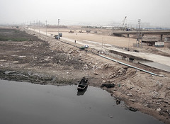
On my walk, I stumbled upon guardhouses that were never staffed by border guards and the chain-link fence that separates pedestrians from Houhai. The entire area had been filled with earth and pumps were busy squeezing out the last of the ocean. Dump trucks rumbled past and people carrying nets biked out to the new coastline. I learned there was a two-week window to catch newborn crabs before they swam out into what remained of the ocean. These baby crabs would be used to stock fisheries in Baoan District. The crabbers carried the crabs in plastic soda bottles that hung around their necks. Eventually, I arrived at Sand River, I came across one of the construction sites for the Shenzhen Western Corridor Bridge, which set me to thinking about the various infrastructures which integrate Shenzhen and Hong Kong. What follows is a longish outline of Shenzhen history as mapped by Shenzhen-Hong Kong checkpoints. You can skip the discussion and go straight to the Western Corridor land reclamation pictures, or you can indulge my sudden urge to document comprehensively the transformation of Shenzhen.
(I’ve just realized that I only use Mandarin and Shenzhen place names in this blog. I promise to start documenting the different names for the sites. I may even talk about what these differences in talk might mean…)
Anyway, the fourth land connection between Shenzhen and Hong Kong, the Shenzhen Western Corridor Bridge was completed in January 2006. The corridor itself should be finished later this year. It is a 3.8 km long dual-carriageway 3-lane bridge connecting Nanshan District to Hong Kong at Ngau Hom Shek. The construction is being overseen by OPAC, a San Francisco based engineering firm. Trying to figure out the actual cost of the corridor is somewhat difficult. According to the China Daily, the bridge cost $US 111 million to build. On their webpage, OPAC estimated that the cost of the Western Corridor Bridge would be $US 400 million. The Nickel Institute website quotes the Hong Kong Highway Authority as putting the estimated cost at $US 2.7 billion. Perhaps the China Daily quote refers just to the cost of the bridge, the OPAC quote to the cost of the entire corridor, and the Hong Kong Highway Authority quote to related infrastructure in Hong Kong. What can be concluded is that the corridor is expensive and somebody is making a lot of money from it.
And making money seems to be the point. The Western Corridor Bridge is part of a larger effort to transform the Pearl River Delta into one of the most vibrant economic regions in the world. On August 28, 2003, at the Foundation-stone Laying Ceremony for the Hong Kong-Shenzhen Western Corridor in Shenzhen, Hong Kong Chief Executive, Mr Tung Chee Hwa said, “Hong Kong and Shenzhen are a key nexus in land transport to the Mainland…The three existing land boundary crossings between Shenzhen and Hong Kong are nearing the saturation point, such that both administrations have agreed to build the Hong Kong-Shenzhen Western Corridor as the fourth land crossing to accommodate growth. Traffic flows at the three existing boundary crossings have increased greatly over the past five years. The average total daily vehicular traffic at boundary crossings is expected to reach 65,000 vehicles in 2006, far beyond the daily capacity of 42,000 vehicles, which the three existing crossings offer now. Upon its completion, the Western Corridor will provide additional daily traffic capacity of 80,000 vehicles, raising the overall daily traffic capacity to 122,000 vehicles, thereby easing the current congestion. And yet, even four land crossings are considered inadequate to meet the future demand arising from further development. A working group drawn from among officials of the Hong Kong, Guangdong and Macao administrations will convene its first meeting tomorrow to press on with the advance preparations for construction of the Hong Kong-Zhuhai-Macao Bridge…”
The figures for vehicular land crossings do not include statistics for all border checkpoints (in order of numbers of passenger crossings)—Luohu, Huanggang, Shekou, Shenzhen airport, Wenjindu, and Shatoujiao. Official Shenzhen customs figures showed entry and exit passengers at the city’s six checkpoints reached 137 million in 2004. Crossings surge during Chinese holidays, especially Chinese New Years, when an estimated 5-6 million people (over a period of two weeks) cross at Luohu alone. During the holiday season, all checkpoints extend hours and increase staff handling document inspection. Each of these crossings has a distinct, but interconnected history that illuminates different aspects of the Shenzhen-Hong Kong nexus as part of globalization. A crude synopsis of the six sites follows and provides a very, very, very rough outline of Shenzhen’s deep history.
(I try to problematize the idea of history with respect to Shenzhen most entries. However, this is the first time in this site that I’m trying to locate Shenzhen with respect to larger currents. I’ve learned how to think about this history from Giovanni Arrighi in his wonderful book The Long Twentieth Century. Helen Siu and David Faure have turned an anthropological lens on this process in Down to Earth: The Territorial Bond in South China. I’ve picked up some online sources that may be helpful and embedded in the following notes. I assume it’s all as reliable as statistics about Western Corridor Bridge finances are.)
In a certain sense, the Luohu checkpoint has been in existence since the leasing of the Hong Kong New Terriories in 1898, when the Sino-Anglo border moved to the Shenzhen River. Previously, the Qing Dynasty had ceded Hong Kong Island and the area south of the Kowloon Mountains to Great Britain in 1842 (end of the first Opium War) and 1860 (end of the second Opium War), respectively. Luohu (Lo Wu in Cantonese) was the first stop on the Chinese side of the Hong Kong-Guangzhou railway, which was built in 1913 and more effectively integrated south-eastern China into the British Empire. So thinking about Luohu leads to thoughts about British imperialism, the transition to the Cold War, and the postsocialist realignment of international political-economies with a focus on East Asia. Suddenly, Shenzhen is neither hinterland nor no man’s land, but vying for the center of global trade. In a recent defense of building the Hong Kong-Zhuhai-Macao Bridge and associated costs, the Executive Director of the Travel Industry Council of Hong Kong, Joseph Tung, has said that the Luowu checkpoint is one of the busiest land crossings in the world, with more than 90 million people passing through it every year.
The Huanggang Checkpoint opened for 24-hour border crossings Jan. 27, 2003, at which point crossing figures surged from 50,000 to 110,000 per day. Buses to and from the Huanggang Checkpoint, connect Shenzhen to six Hong Kong destinations, including the Hong Kong airport. Since 1995, Huanggang has been the primary conduit between Shenzhen and Hong Kong Disneyland. Until the construction of the Western Corridor Bridge, Huanggang was the newest of the land crossings. It is interesting because it was part of a geographic shift in Shenzhen from “Downtown” referring to Luo Hu to the new “City Business Center” in Futian. The shift began in 1996, when the Shenzhen Municipal Government accepted plans for the new CBD. Michael Gallagher gave a talk about the Shenzhen CBD in 2002. But for a sense of the scale of this transformation and the debate about it, google 深圳CBD and check out all the different sites. Thus, the shift from Luohu to Futian allows for specifying the differences between a Hong Kong centered development in the early 80s to a more diffuse integration of the region, and therefore a more Mainland-centered pattern of economic development.
The most expensive connection between Shenzhen and Hong Kong, the Shekou ferry makes 13 round trip voyages a day, except during Chinese New Year, when the number of trips increases to accommodate the numbers of visitors. An additional 8 daily voyages connect Shekou to the Hong Kong airport. Most frequent passengers on the ferry are Shekou-based foreigners. The Shekou Ferry is interesting for a number of reasons, most related to the role that China Merchants has played (by way of Shekou) in the development of Shenzhen. The role of China Merchants then leads back to Luohu and questions of national development first raised during the later years of the Qing Dynasty. As of 2004, China Merchants has posted its own historical archive online, which highlights the role that commerce and international relations have played in modern Chinese history.
Along with Hong Kong, Guangzhou, Zhuhai, and Macau, the Shenzhen Airport is one of five international airports in the Pearl River Delta. In terms of passengers served, it ranks behind Hong Kong and Guangzhou. The five international airports have been built within a radius of 25 km. illustrating the level of competition and inter-city rivalry that has characterized development in the Pearl River Delta, rather than regional cooperation and planning. Moreover, the redundant infrastructure in the Delta has led to serious environmental problems, according to a report by K. C. Ho and C. S. Man.
Wenjindu is primarily a crossing for goods between Shenzhen and Hong Kong. It was opened in 1950, as part of the new Mainland government’s strategy to bring hard currency into the country. Throughout the Mao-era, agricultural products flowed from the Mainland into Hong Kong, a development strategy that has been more fully exploited since Shenzhen’s establishment. So thinking about Wenjindu allows one to question commonly held understandings about China’s so-called isolation during the Mao era outside of the obvious connections with the former Soviet Union and other socialist and third world countries. In the era of Avian flu, Wenjindu regularly appears in Hong Kong news reports as the site where chickens and other poultry cross the border. With suspicious regularity, indeed with an almost ritualized compulsion, Hong Kong public health officials regularly express astonishment on conditions north of the border.
So a rough outline of Shenzhen’s history with respect to the construction, use, and re-appropriation of Shenzhen-Hong Kong border checkpoint infrastructure. It touches upon British imperialism, the Cold War, the East Asian economic miracle, the rise of China as a global player, international epidemics, and the concomitant transformation of the environment. This is how we make our world, one reclaimed special zone at a time.
Back in Shenzhen
After two and a half months in North Carolina, I’ve finally returned to Shenzhen. My first photo opportunity was, not unexpectedly at Shenzhen University, where I first came in 1995. At the time, University lands abutted the bay, and oyster fishing families lived on the strip of land between the University wall and coast. I remember walking along the path and looking out toward the horizon where dump trucks hauled earth to build what is now the Binhai Expressway. Later, I learned that the entire western coast was being transformed through the Houhai land reclamation project.
Today, I came upon Shenzhen University’s new South Gate, which connects the University to Houhai Road. Carved into the land, the gate formalizes this space, makes it part of a larger pattern, when before it had been a wild border, unkempt, untended, with tendrils of purple flowers bursting open. As I walked, I remembered this space ten years ago when fish gasped the last drops of water left. Five years ago, I crawled through a hole in the temporary fence that separated the Houhai Road construction site from the campus, clay oozing into my shoes. I also remembered walking past the frame of a demolished building and thinking I should get a camera and take a picture—document the transformation, not simply being a kind of anthropological imperative, but an attempt to inhabit this space.
Lately however I’ve been wondering about my fascination with Houhai. Indeed, Houhai has been one of my favorite haunts. I visit regularly to see what has changed and what I still am able to re-member as another housing development or shopping mall rises. Yet, I don’t spend any time systematically investigating the actual construction of Houhai. I haven’t tracked down the engineers who planned the project and don’t intend dig through the various urban plans to track the discrepancies between planned and actual land use. I’m not sure if I even want to theorize about the meaning of globalization or environmental reconstruction from what I’ve seen of Houhai.
Instead, I seem compelled to pick my way through the mud and take pictures of cranes and transported dirt, the remnants of squatter housing and the lush vegetation that flourishes whenever dust is allowed to settle. I am obsessed with how the Houhai land reclamation project continues to encroach on my cognitive maps of the world and my place in it. And perhaps there’s rub. I don’t know how much of myself I can hold onto as memories that were once constituted through another landscape have already been razed. Two new pictures from the transforming border between Shenzhen University and Houhai are up at: http://pics.livejournal.com/maryannodonnell/gallery/00010qpw. The picture in the corner is for reference; I took it over three years ago from more or less the same place.
You can also visit houhai ghosts, a previous entry that shows these changes even more clearly: http://pics.livejournal.com/maryannodonnell/gallery/00002c4h.

