So one of the ongoing transformation in Shenzhen has been the transvaluation of the coastline from a space of production and transportation to a space of consumption and international logistics. In practical terms, it means that Shenzhen residents have been “landlocked” despite having a 162 mile (260 km) coastline. Inquiring minds want to know: how did that happen?
Some background:
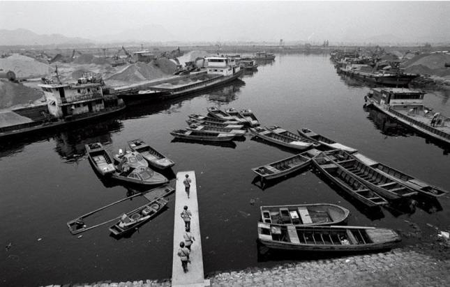
These were the Shangbu Docks in the early 1980s. At the top of the image was the Shenzhen River, just before it opened into Shenzhen Bay–the mountains in the distance are on the Hong Kong side of the river and bay. It is estimated that as much as 90% of the materials for the construction of Luohu-Shangbu (Shenzhen 1.0) came in via Shangbu for several reasons. First, Shenzhen’s downtown road grid was not in place until the mid 1980s. Second, the city’s connections to the rest of the country (primarily via Highway G107) would not be up and running until the 1990s. And third, the rest of the PRD did not start building extensive road networks until the 1990s. Together, this meant that until roughly 2000, supply lines from other cities in the PRD to Shenzhen continued to rely on historic docks. Not surprisingly, the 1990s were the heyday of smuggling in the city. During this decade, locals still had access to their boats and docks, moving easily between Shenzhen and Hong Kong. At the same time, the increase of migrants, especially after 1992 meant the market for Hong Kong goods kept growing in place. It was not so much market expansion (for smuggled goods) and intensification of local markets through population growth.
In other words, from roughly 1980 through 2000, the transition from Bao’an to Shenzhen could be understood as the transition from being a network of coastal settlements to being a landlocked city. The above image was created out of a walk along the Mangrove Coast Park, which was ongoing for over a decade. The chain fence prevented people from leaving the sidewalk to walk along Shenzhen Bay’s northern coast. It also served as a marker of where the old new coastline used to be. Below are images of the northern coast of Shenzhen Bay on July 28, 2009. This was no longer a working coastline, but rather a place of “coastal pleasures,” including ice creams and fresh coconut milk. Note also the old border towers that were built but only ever used as housing, not to guard the border, which shifted south too quickly.