the photography of he huangyou

A current exhibition of the photography of He Huangyou (何煌友), Shenzhen Memory is something of a historical mashup. It includes many of He’s most-well known photographs, which have shaped our visual imagination of the Shenzhen before and at the cusp of reform. These photographs are well worth seeing in person. However, the exhibition neither contextualizes nor places the photographs in chronological order, leaving interpretation up to the viewer. This form of representation may in fact conform to what we know of how memory works–it is highly personal and unreliable–but it makes it difficult to place the images into larger histories. It feels as if we are suddenly viewing the illustrated introduction to the “fishing village to world city” narrative without bothering to mention that the exhibition includes pictures from at least three different coastlines and two different epicenters of reform (Shenzhen and Shekou).

Continue reading

fuyong new village / bao’an road

It’s instructive to jump off the number 11 subway line, once its passed the airport station. In Bao’an District, the No 11 line runs parallel to Bao’an Road, which delineates the inner border between the older, historic village settlements and their industrial parks. East of Bao’an Road, one heads toward the Pearl River, land reclamation, and scattered reminders of this deeper history. West of Bao’an Road, one heads through large industrial parks toward National expressway G107, which was the road that first connected the original Special Zone to Guangzhou via Songgang (images of a 2008 walk, here). At Nantou Checkpoint, National Highway 107 becomes Shannan Road and a fast track to the inner district real estate boom. Continue reading

downtown

This slideshow requires JavaScript.

Downtown Shenzhen used to be the area around the Luohu train station, moving east (toward the Wenjingdu border crossing) and west (toward Caiwuwei, the site of Baoan County Headquarters before 1979). Caiwuwei remains the Municipality’s financial center. However, there are still traces of early Shenzhen scale and place names to be found, even when standing at the intersection of Shennan and Hongling Roads, site of the billboard to Deng Xiaoping and the promise of stable political policies. Impressions, above.

tangtou, baishizhou


tangtou old housing, new village

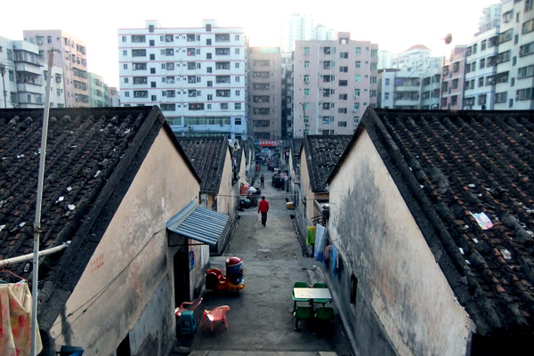
Baishizhou has the distinction of being Shenzhen’s “city that isn’t a city, village that isn’t a village (城不城,村不村).”

The first stop (bus or subway) after Windows of the World themepark, Baishizhou has come to refer to a 7.5 sq km sprawl of handshake buildings that was originally part of the “Shahe Overseas Farm (沙河华侨农场)”. This highly congested and irregularly built area is also the first stop for many new migrants to Shenzhen because of its central location, convenience, and lowest of the low priced housing.

Inquiring minds ask, “How did (one of) Shenzhen’s most beautifully landscaped high end residential, tourist and arts area (OCT) end up next to what is acknowledged to be one of the city’s largest slums?” Continue reading

shennan rd, part 2

Walking further east on Shennan Road, from the old city hall building toward the train station, what becomes clear is the extent to which we might describe urbanization in Shenzhen as a process of “the city surrounds the countryside”. This phrase, a reworking of the Maoist revolutionary maxim that “the countryside surrounds the city” points to the geographic shift that has enabled the transition from rural revolution to urban reform. Under Mao, revolution was understood as starting in rural areas and spreading to urban areas. Although the revolutionaries aimed to modernize China, they nevertheless first occupied rural areas and then liberated urban areas. Thus, the Maoist slogan referred to a military strategy. In contrast, under Deng, reform was understood to entail freeing up urban processes in order to allow the economy to develop naturally. Consequently, the Shenzhen inversion of Maoism makes explicit the shift from political to economic concerns, even as it maintains the occupation of land as central to historic process. All too crudely, we might say that for Mao, the occupation of territory was conceptualized as a political process that was to bring about economic change. In contrast, under Deng, the occupation of territory was understood as an economic project, which had political consequences.

What is interesting to think about in terms of Shenzhen’s rural urbanization, is how the rural and the backward (in need of modernization) constantly change as new areas are developed. Thus, areas that ten, fifteen years ago were considered modern are today looking worse for wear. These now constitute the relative rural, which needs to be updated. The process of ruralizing the urban with respect to newer, taller, more modern urban spaces creates a particular kind of urban geography, one of poorer eddies, or (quite literally because they stand in the shadows of taller buildings) dark holes that are surrounded by shiny new buildings. The relative poverty of these pockets is of a different kind than the kind of isolation that has taken place in Shenzhen’s new villages, which are actually well off. Instead, these pockets are the manifestation of a necessary dialectic in which progress is measured by overcoming what already exists—there is a necessary surpassing of these older areas.

I think I’ll write more about the creation of ghettos and its particular manifestation in Shenzhen in another entry. Today, I want to call attention to the ongoing contradictions, but also the shiny brightness of Shenzhen construction during the 1990s. These images can be seen at: http://pics.livejournal.com/maryannodonnell/gallery/0000prqq

inscribed history, briefly: shennan road

Shennan Road is the oldest east-west artery in Shenzhen, until a few years ago when the opening of the northern loop and the Binhai road, it was both Main Street (in the sense of the center of town activities) and the main artery for transporting goods and people from one side of the city to the other. Today, most trucks travel from factories along the northern loop, crossing the border at either Wenjindu or Huanggang, and most cars and all express buses travel along Binhai. However, Shennan Road has maintained its symbolic and functional importance in the organization of the city.

This weekend, I went for a walk along the strip of Shennan Road between the old city hall and the recently opened new city hall. There’s much to be said about the difference between the two buildings, but the point I want to emphasize here is the inscription of history through architecture that is visible along this strip. It is, in many respects a history that can be understood through the movement from the low, concrete municipal building (a Stalinist concrete block), representing the idea of Shenzhen as a manufacturing center to the post-modern glass and steel of the new municipal building, which points to Shenzhen’s aspirations in global finance and management. All this to say, throughout the strip one encounters concrete factory buildings and modernist office buildings that abut newer, taller, and more expensive buildings.

This twenty-five year history is also the history of replacing the collectivist economy with a market economy. This history, while less visible than the progression from manufacturing to finance manifest in the city halls, is nevertheless a structuring feature of this bit of land. This structuring has several levels.

• First, twenty-five years ago, when Shenzhen planners first approached the project of opening the west, they only marked the land from Luohu train station to the Shanghai Hotel. That is to say, for many years when Shenzhen residents said they were going into town, they meant the area between the train station and the Shanghai hotel. This means that the new city center has been moved from the original downtown to what was previously a leechee orchard outside the scope of the original urban plan. Traces of this other history remain in Shenzhen’s center park, which stretches alongside the new city center, large tracks of which are still used to cultivate leechees.

• Second, the transfer of commune land to urban work units predicated this transformation. The Ministry of Aviation developed the area on which the Shanghai hotel was built. The Ministry of Aviation annexed this land from the Shangbu Commune, which is memorialized across the street from the Shanghai hotel in the form of the Shangbu Building, a concrete skyscraper from the mid-1980s.

• Third, this transformation entailed economic re-orientation. The production of electronics for foreign markets financed the construction of the Saige building, which towers over the Huaqiangbei area. Throughout this area, entrepreneurs continue to sell electronic products, which are no longer primarily manufactured in this area. Instead, this area has become a center of leasure and high-end consumption, symbolized by the Zhongxin Plaza, built across the street from the old city hall.

A brief reading of the landscape that unmakes the often heard phrase “Shenzhen has no history”. It also reminds me that simply driving from one end of town to the other involves the reiteration of history through spatial landmarks. What gets confusing in Shenzhen is the speed at which buildings come and go, thereby making us think everything is always new, enabling us to forget what was previously here. It is also a history that connects with the history of landscaping that I talked about in a previous entry. What seems to boggle the mind is the speed, and yet the history is there. How is it we become trained only to see what is new? And how is it that historic difference seems not to matter (in all senses of the word)? What seems important is the ongoing replacement of one set of buildings and environments and lifestyles with another set: I am reminded of how the American West was, in a manner of speaking, won and how then what remained were ghost towns and abandoned mines, farmers with rundown farms.

(I remember when the Shanghai hotel was given new façade over 10 years ago. During the mid 1990s, there was a time when old concrete buildings were dressed up to look like postmodern architecture, but that then gave way to simply razing large areas of land and building newer, taller, and certainly shinier buildings.)

For an incomplete view of this strip of Shennan Road, please visit: http://pics.livejournal.com/maryannodonnell/gallery/0000k20k